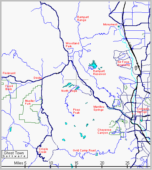

Trail Reports and Maps
Monument Area
The town of Monument is twenty miles north of Colorado Springs and is the
gateway to the only road leading into the mountains between Colorado Springs
and Sedalia. This fifty mile mountain wall has plenty of trails but most are
too rough for bikes and are hidden behind private property. Once you get
above the initial "wall", the plateau of Rampart Range is a hilly region of
rock formations and old jeep roads where bikes can explore all week long.
The Monument and Black Forest area is also a great place for road rides
through beautiful hills and forest of the high plains.
Mount Herman Trail The short Mount Herman Trail climbs up the backside of Mount Herman, with great views of the front range.
Mount Herman Road The Mount Herman Road is the access to the Rampart Range Plateau, and is also a great workout on a bike.
Palmer to Larkspur The paved roads from Palmer Lake to Larkspur is a scenic ride through hills, meadow and forest.
Black Forest Loop Black Forest is a grid of roads that provide a variety of loops through scenic hills and forest.
Air Force Academy The smooth roads of the Academy make a scenic and historic loop through a popular tourist area with great views.
Santa Fe Trail This old railroad bed is a scenic ride from Palmer Lake to the Air Force Academy.
Manitou Area
The town of Manitou Springs is just
west of Colorado Springs, at the entrance to Fountain Creek Canyon.
This area is a gateway to trails on the north and east sides of Pikes
Peak, with access through the towns of Manitou and Cascade. These
trails are rugged and popular, making them better for hiking than for
biking. But there is something for everyone in this area, including
long hikes, short hikes, mountain biking, long-paved downhills,
tourist traps and some of the best rock climbing on the front range.
Barr Trail The Barr Trail is the tallest trail in the state, climbing twelve miles from Manitou to the top of Pikes Peak, 7000 feet above.
Mount Manitou Trail Mount Manitou is a shorter version of the Barr, climbing three miles with good views of the foothills.
Waldo Canyon Trail A little farther up Route 24 is the popular Waldo Canyon Trail, which loops through a scenic forest area.
Route 24 Downhill For a fast tour of Route 24, try coasting fifteen miles from Woodland Park to Colorado Springs, a 2000 foot drop.
Pikes Peak Highway The road to the top of Pikes Peak is a spectacular drive, with incredible views in every direction.
Garden of the Gods Garden of the Gods is a park full of huge rock formations and trails. Great for driving, hiking or biking.
Cheyenne Canyon
In the southwest corner of Colorado
Springs is the deep and rugged Cheyenne Canyon. Several canyons climb
into the mountains and forest, in an area littered with trails and
dirt roads. This popular hiking and biking area offers a web of
connecting trails, to a varitey of sights - creeks, waterfalls, canyons,
forest, mountain tops, old tunnels, old mines, and great views along
almost every trail. This area is popular but there's enough room for
everyone, and if you venture only a few miles from the car, you'll
probably be all alone. The trails are a little rugged, and beginners
will need to plan ahead before trying this area.
Gold Camp Road Nine miles of Gold Camp Road have been closed and it now makes a great bike path through mountains, forest and old tunnels.
High Drive This ten mile loop offers great views as it climbs into the hills, passes through two tunnels and returns through the forest.
Multi-Use Trail This fun trail weaves around Mays Peak like a roller coaster and returns through two tunnels on Gold Camp Road.
Bear Creek Trail This popular hiking trail follows the scenic creek for several miles up the canyon and into the forest.
St Marys Falls A mile of dirt road and another of trail lead to this scenic destination. A good mix of easy/hard, open/forest along the way.
Mount Buckhorn Trail A good workout on a good trail to an overlook above Cheyenne Canyon. Great views of the mountains, canyons, forest and town.
Helen Hunt Falls A scenic waterfall next to the road and then hike to another falls and an old tunnel.
Gold Camp Road Area
A hundred years ago Gold Camp Road
was the railroad that connected Colorado Springs to the gold mines at
Cripple Creek. Today, this secluded twenty mile stretch of road twists
through some of the areas most beautiful country. Several trails and
jeep roads head to a variety of destinations in an area that gets far
less use than those closer to town. The road its self is an exciting
bike ride for those with energy, and a ride home. It borders the
Pikes Peak massif to the north, and the Beaver Creek Wilderness to the
south, with Cripple Creek to the west.
Mount Baldy Road The 2000 foot climb up Almagre Mtn is sure to give even experts a good workout. The 12,000 foot views are almost scary.
Emerald Valley Road This jeep road follows the creek through a beautiful green valley with towering peaks on all sides.
Gray Back Peak This easy trail is for those who want a good view without all the work. Overlooks Emerald Valley and Gold Camp Road.
St Peters Dome This rocky peak straddles the Upper and Lower Gold Camp Road valleys, with great views of the mountains and town.
Mt Big Chief This little known trail takes you to one of the most impressive views in the area, towering over a huge area of wilderness.
Seven Lakes Road Be prepared for a good workout and great views as this dirt road climbs a ridge overlooking the off-limits Seven Lakes.
Mount Rosa Trail Hike to the pointy top of a nearby mountain.
Phantom Canyon Road Ride 30 miles through a remote canyon.
Woodland Park Area
The Woodland Park area north of
Pikes Peak is a huge expanse of mountains and forest. Though it has
few trails, a network of old logging roads lead to all corners of the
forest, and can provide weeks of exploring for those with a map and
strong legs. The long trails with no clear destination make this area
more popular with bikers than with hikers, though there are few of
either. This network of secluded jeep roads is the Front Range's best
kept secret for mountain bikes.
Westcreek Road The road north to Westcreek is one of the prettiest rides in the area, following the valley through meadows and forest.
Rampart Reservoir The twelve mile loop around Rampart Res is one of the most stunning and enjoyable trails in the whole region.
Hotel Gulch Trail This five mile jeep road climbs out of the Route 67 valley to the Rampart Range plateau, passing the creek and ponds.
Balanced Rock Trail This jeep road makes a loop on top of the Rampart Range plateau, with good views in all directions.
Rainbow Falls Trail This scenic eight mile jeep road is an easy ride in the forest north of Woodland Park, and has connections to more roads.
Devils Head Trail This giant dome of a peak towers over the forest like a skyscraper. The exhausting trail then climbs a hundred foot fire tower.
Catamount Creek Trail Hike up a steep rocky mountain side along side a churning creek.
Lovell Gulch Trail Hike a scenic trail in the forest, right in Woodland Park.
Ice Cave Road Ride a jeep road through the Rampart Plateau.
Manitou Lake Park Hike, fish or picnic around a pretty mountain lake.
Mueller State Park
The Mueller-Divide area is a high plateau where big scenic meadows meet the
western Pikes Peak foothills. The 9000 to 10000 foot elevation can be exhausting
for newcomers, but makes a cool getaway even in a hot summer. Cold winters
make this a popular cross country skiing area. The area is centered
around Mueller State Park, the area's most popular camping and hiking
spot. The west side of Pikes Peak is a little rough for bikes but
has a few trails for hikers and rugged bikers.
Crags Trail The short Crags Trail is a fun climb up a rocky outcrop with good views of the Ute Pass countryside.
Pancake Rocks Trail This rough trail climbs a rocky hillside with strange rock formations, and great views from Mueller to Cripple Creek.
Dome Rock Trail This long and scenic trail, on Mueller's south side, follows the creek to big rock formations and a Big Horn Sheep area.
Mueller S.P. Mueller is one of the biggest state parks in Colorado and is webbed with trails for hiking, biking, and skiing.
Mueller North Loop Ride the scenic hills of northern Mueller Park : Cheesman Ranch Trail and Buffalo Rock Trail.
Mueller South Loop Coast down an exciting trail in southern Mueller Park : Rock Pond Trail, Cabin Creek Pond, Dome Rock Trail.
Divide to Florissant Florissant is a quiet area of big meadows and easy trails, and the country's biggest collection of fossil tree stumps.
Farther West
A little west of Mueller is Florissant and Elevenmile Canyon. The Florissant
area is big green meadows with rolling hills and forest, turning into giant
rock formations farther south. Elevenmile Canyon is home to the Platte
River and big cliffs, a great place to spend a weekend.
Cripple Creek to Florissant This is a beautiful area of rocky domes poking above green pastures and forest - an exotic look that's best appreciated on a bike.
Elevenmile Canyon This exciting canyon and river is loaded with things to do - Hike, bike, climb, fish or camp.
Twin Rocks Trail This new trail with big rock formations is one of the most interesting in the Florissant Fossil Beds.
Boulder Creek Trail Hike the meadows and hills of the Fossil Beds past a pond and big rocks.
Manchester Creek Road Ride a smooth trail and jeep road in the hills of northern Teller County.