9 Miles, Out/Back 8300-8700 Elevation

9 Miles, Out/Back 8300-8700 Elevation
Note - As of August 13, 2000, this trail has been closed to bikes. However, horses and hikers are still allowed.
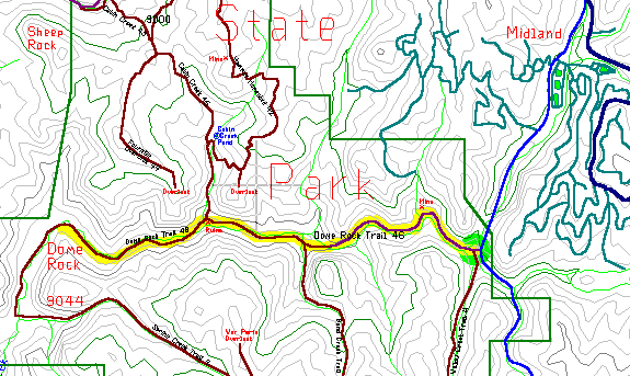
In the southwest corner of Mueller State Park is Dome Rock. The four mile trail is one of the most fun and scenic in the region, with seven creek crossings and towering cliffs above. The first 3 miles of the trail were open to bikes, but now you'll have to hike all 4 miles to the dome, towering 700 feet above the trail.
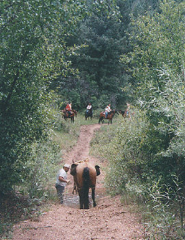
Thirty miles west of town is Divide village, turn south and drive seven miles on Route 67 and Fourmile Road to the Fourmile Creek Trailhead (go past the park entrance). Park in the north area and ride west into the canyon, and be prepared to share this popular trail with hikers and horses.
The trail starts in a deep valley with a sizeable creek at the bottom. It starts fifty feet above the creek but shortly drops down and then closely follows the creek the rest of the way. The trail is in good shape the whole way (and was very bikeable before they were banned). The beautiful canyon is full of trees, water and interesting rock formations.
The trail crosses the creek seven times, evenly spaced every half mile. Some crossing are about a foot deep and too wide to jump. Half way down, a beaver pond has flooded the trail but a smaller trail goes around to the north for those who don't want to wade through. Plan on getting your feet wet and having a good time. The first half of the trail is kind of steep but it later flattens out, passing a series of beaver ponds along the flat part.
Even though Dome Rock towers over the area, you can't actually see it from the trail. After 3.4 miles is a fence, bike rack and sign warning bikers to stop at the wildlife area boundary. Continue hiking as the trail wraps west then south around the Dome. This part is flat and wide, and after turning south Dome Rock comes into view. After a mile from the bikes the trail pases directly under the Dome, towering 700 feet overhead. This is as close as the trail gets and is a good place to turn around. For those with a little more energy, continue the hike around to the Spring Creek and Willow Creek Trails. This increases the trip back to six miles.