4 Mile Trail, Out/Back 9900-11200 Elevation
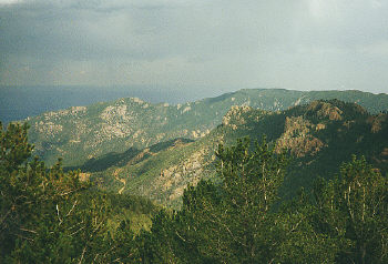
This little known trail south of Pikes Peak has some of the most impressive views in the whole region. The strenuous climb will wear out even healthy hikers, but the stunning 360 degree panorama is worth every step.
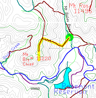
This trail is hidden at the start of the Mt Baldy road. To get there drive south and then west on Old Stage Road. After seven miles Old Stage turns into Gold Camp Road. After six more miles the Mt Baldy Road is on the right, across from the gate to Rosemont Reservoir. Go 2/10 mile up the road to a pull-out on the left. (Walk if you don't have a 4wd) Cross the creek and look for the old pipeline trail, it's arrow straight and pretty obvious.
This old pipeline trail goes southwest in a straight line for a quarter mile and then ends at a ravine, where it crosses the real Mt Big Chief trail. Turn right and the trail starts its long steep climb.
This part is fairly straight but steep and rocky, and appears to end at another ravine but actually veers to the right, you'll have to pay attention. In the half mile to the top of the ridge, the trail is narrow and in good shape but gets a little vague at times. Even though the trail zig zags thirty times on it's way up, it's still steep enough to require frequent rest stops.
Once on top of the ridge the trail disappears for a while. Note the old log wall, it points the way back down. Head south and the trail starts again, lined with rocks. Follow the right side of the ridge and after a quarter mile you'll come to the first summit. The view from here is spectacular but blocked by trees.
The second summit is a rocky peak poking above the trees, where the panorama is wide open in every direction. The southern face is a near-vertical 500 foot drop, 1200 feet above Gold Camp Road. The tremendous view from this 11200 foot peak is one of the most breathtaking in the region. To the east is Colorado Springs and Fort Carson, to the west is the Cripple Creek area, and to the south, past the nearby foothills, is the Arkansas River Valley and the Wet Mountains.