10 Mile Trail, Out/Back 9500-11300 Elevation
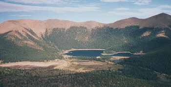
Seven Lakes is part of the Colorado Springs watershed and closed to the public. But the 3.5 mile access road is open and makes an exhausting climb through pretty country. At the end of the road a trail continues farther up the hill to Bull Park with even better views.
To get here, drive south on Old Stage Road to the junction with Gold Camp Road. Continue west on Gold Camp Road for thirteen miles to the junction called Clyde. There's a house, pond and road on the right. Park in the clearing south of the road and ride up the road going north, past the ponds.
The road is in ok shape, but it climbs 1300 feet in 3.5 miles, peaking out at nearly 11,000 feet, enough to wear out anyone. It's a good challenge for someone who wants to test his leg strength, rather than his patience on those boulder strewn trails. The road follows the creek up the scenic valley, with cliffs on the right and forest on the left. Along the way are a dozen great places for a picnic.
The road comes to an end at a closed gate where you'll find trails going both east and west. The Bull Park Trail to the west is the better of the two, so we'll take it, but obviously the weary among you can quit right here. The trail has a deep creek crossing at the start, but can be jumped in the right spot. The trail isn't too bad at first, but at each bend it turns a little more rocky, turning into a bed of rocks after about a mile - a punishing slog for those who can actually ride it.
After 1.7 miles, the trail tops out at a saddle that overlooks Seven Lakes to the east and Cripple Creek to the west, impressive either way. If you want to hike the hill to the north, you'll be rewarded with a stunning view of Pikes Peak from an angle rarely seen, towering over the Seven Lakes.