7.5 Mile Trail 8400-9600 Elevation
Note - As of August, 2000, the Dome Rock and Cabin Creek Trails have been closed to bikes. This story was originally written for bikers but the trail is still plenty scenic for hikers.
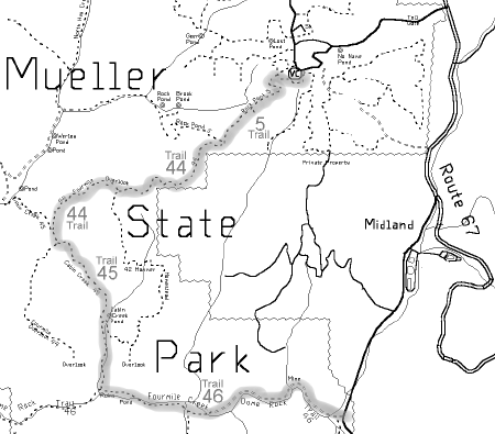
The rugged terrain of central Mueller is a load of fun on a bike, if you're going in the right direction. These wide trails zoom through thick forest filled with good views, creeks and rocks, but be sure to do this exciting ride downhill. This route will change names five times, so bring a good map or risk guessing your way through a real maze.
From the east end of the visitor center parking lot, head south and west past the kiosk on the Rock Pond Trail. This seems to be the only trail in the park that isn't marked, but 200 yards later it's correctly labeled as Trail 5. At that point you're on one of the many old jeep roads that lace the park, cruising through thick forest on a remarkably smooth path eight feet wide.
After a mile, bear left on Trail 44 which turns into a real rollercoaster as it drops deeper into the valley. Some of the uphills are quite steep, enough so that I chose to walk up one of them. But the downhills seem to go on forever, dropping 1200 feet over five miles by the time it runs into the Dome Rock Trail.
As the valley gets deeper, the forest gets greener and the rocks more mossy. It's not quite Ireland, but this is as lush as trails get in this region, no doubt helped along by the heavy rains of last summer. Plenty of rock formations pop into view, but the distant peaks fade away as the valley walls get taller.
Note - The rest of this report is on trails that are now off limits to bikes.
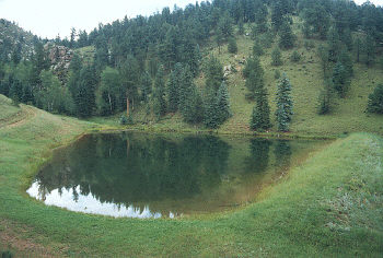
After about three miles bear left on Trail 45, where the well groomed road turns into a grassy single track, and then runs into the Cabin Creek Pond. This is one of the biggest ponds in the park, in an impressive setting of tall cliffs and trees. This idyllic setting is short lived as the trail shoots into an ugly downhill of steep gravel where most will elect to walk their bikes.
At mile five, Trail 45 runs into the Dome Rock Trail (trail 46). Turn left and start the long climb back to the highway. This is the most exciting trail in the park, following a sizeable creek through a towering valley of rocks, trees and beaver ponds. Cross the creek four times, zoom through an ankle deep beaver pond and then make the final climb above a boulder strewn cataract that pops you into the parking lot.
Mueller State Park is 25 miles west of Colorado Springs on Highway 24, then turn south at the Divide stop light and drive four miles to the entrance on Highway 67.