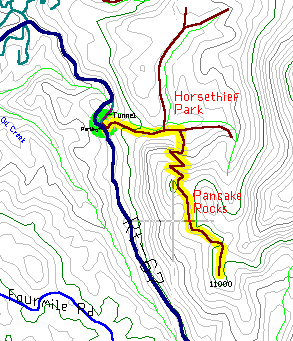
6 Mile Trail, Out/Back 9700-11000 Elevation
Pancakes Rocks is a rocky area 1200 feet above the tunnel on Route 67, south of Divide village. This interesting hilltop has good views of the forest west of Pikes Peak and the Cripple Creek valley. The trail is steep and in bad shape, making this secluded trail more popular for hikers than bikers.
Divide village is 25 miles west of Colorado Springs on Route 24. From there, turn south on Route 67 and drive ten miles to the Lil Ike tunnel. Park in the small parking area just past the tunnel. Get out the bike and ride up the trail to the southeast, which bends back north and goes over the tunnel.
This trail is smooth but climbs rather steeply into the hills, following the hillside above the creek. The mile long climb comes to a pretty meadow called Horsethief Park where the trail splits several times. Pass the first fork, which crosses the creek, and turn right at the second fork. A sign marks the spot but it's still hard to find - the forest floor is all open and everything looks like a trail.
Once the trail if found, the punishing climb begins. The steep rocky trail zig zags its way up the mountain side and over boulders, logs and gravel, requiring the bike to be walked repeatedly. With its top at nearly 11,000 feet this is one of the highest trails in the area and even the rideable spots are a workout. When the trail crests the top, it runs into an area of rock piles eroded into stacked water balloon shapes. This is as far as most people go, but these rocks aren't the actual Pancakes. The real ones are a mile farther down the trail and not any more scenic. Take time to climb on the rocks and take in the great views of the green hills to the south and west, and the continental divide 80 miles away.
Once on top of the hill, the trail winds southward along the hilltop for about a mile without climbing or falling much, passing several pancake areas and always with good views. The last rock pile is the one called Pancake Rock, after which the trail runs into private land, (there should be a sign), and you'll have to turn back.