6 Mile Loop 7500-8200 Elevation
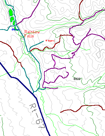
The drive north of Woodland Park is a beautiful ride through a wide forested valley with meadows, lakes, hills and forest. Eleven miles north is the creek and ponds of Rainbow Falls Park, where several jeep roads lead into the mountains and forest. We'll be following an easy six mile loop with good views of the valley.
From Woodland Park, turn north on Route 67 at the west-most stop light, the Gold Hill Plaza. After eleven miles turn right at the dirt road labeled Rainbow Falls Park. Cross the creek, then park near the big bare spot that looks like a motocross track. Rainbow Falls is the main road going north, our jeep road is the one going east, occasionally labeled FR 348.
This whole section of forest to the north and east is a network of old logging roads that is now one of the area's most popular dirt bike areas, with something like 200 miles of hilly tracks. Plan on seeing plenty of motorcycles, but they quickly lose themselves in the forest, leaving the closer tracks fairly free for us slowpokes.
The two mile access road has turned its self into an ad-hoc campground, with dozens of tents and campers hidden in the trees each weekend. Follow their lead and bring your own gear, and spend the weekend exploring this beautiful valley. There's hills for hiking, rocks for climbing, a creek for fishing, and a hundred miles of jeep roads.
From the motocross parking lot head east, which is into the forest rather than up the valley. As the road climbs through the first mile of forest, you'll pass by tents and campers every hundred yards or so. This is more fun than it sounds, with barbarque and campfire smells, and little kids waving as you ride by. One five-year-old stopped to show me a log mauled by "bears". I didn't ruin her excitement but it was really the work of a chainsaw.
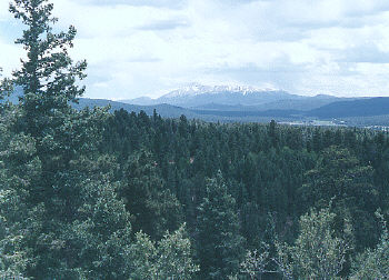
This short jeep road has a confusing number of side trails shooting off in all directions. Most of these go to overlooks or campsites, but some link up to other forest roads. Be sure to follow FR 348 for the first 3.7 miles. Between miles 2 and 4, the road is near its high point, with several short trails leading to great photo spots of Pikes Peak rising above the valley.
At mile 3.7 turn left, off of FR 348 and onto an unnamed but wide track going west. This sandy jeep road runs 1.5 miles downhill and back to the Rainbow Falls Road. The closer you get to the bottom, the more campers you'll find. It meets the main road near the midpoint of the valley, and then it's one last mile down the lush meadow with the creek to the right and rocky hills on both sides.