

|
The Front Range on CD-ROM Map Book and CD-Rom |
|
|
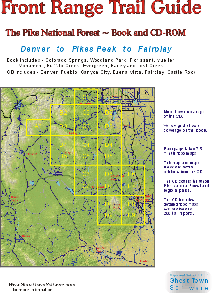
Note, the Trail Guide CD and Map Book are no longer available. Zoltan's Trailguide is still available in stores throughout Colorado Springs. New for 2003 is this 24 page map book with the Trailguide CD included inside ! This 8 1/2 X 11 inch book has two dozen high resolution maps of the most popular areas in the Pikes Peak region. Each page is 10 X 14 miles - which is two 7.5 minute topo maps per page. The CD contains 200 Meg of maps, photos, reports and other features that aren't practical to download from this web site. The CD and book are available in stores throughout the Pikes Peak region or directly from this web site. For Windows 95 98 XP NT 2000. ( We don't have a Win 3.1, Mac, or Unix version ) The Trail Guide CD contains the region's most detailed trail map software. The trails have been manually corrected with the most up to date routes. The maps are fully customizable and scaleable for a view 1 mile wide to 50 miles wide. Version 2 now uses full color terrain shading for the most beautiful maps you've ever seen. Click right on the map to pop-up hundreds of reports and photos. 200 trail reports are taken directly from Zoltan Malocsay's well known guidebook : Trails Guide - Denver to Pikes Peak Dozens of additional reports describe biking on popular jeep roads and country roads in the area, and more than 400 beautiful photos show what you can expect to see along the trail. The maps, reports and photos together provide extensive coverage of the entire Pike National Forest, nearby parks and open spaces. $25 - Trail Guide CD and Map Book $20 - Trail Guide CD $20 - Trail Guide Book $30 - CD and Book |
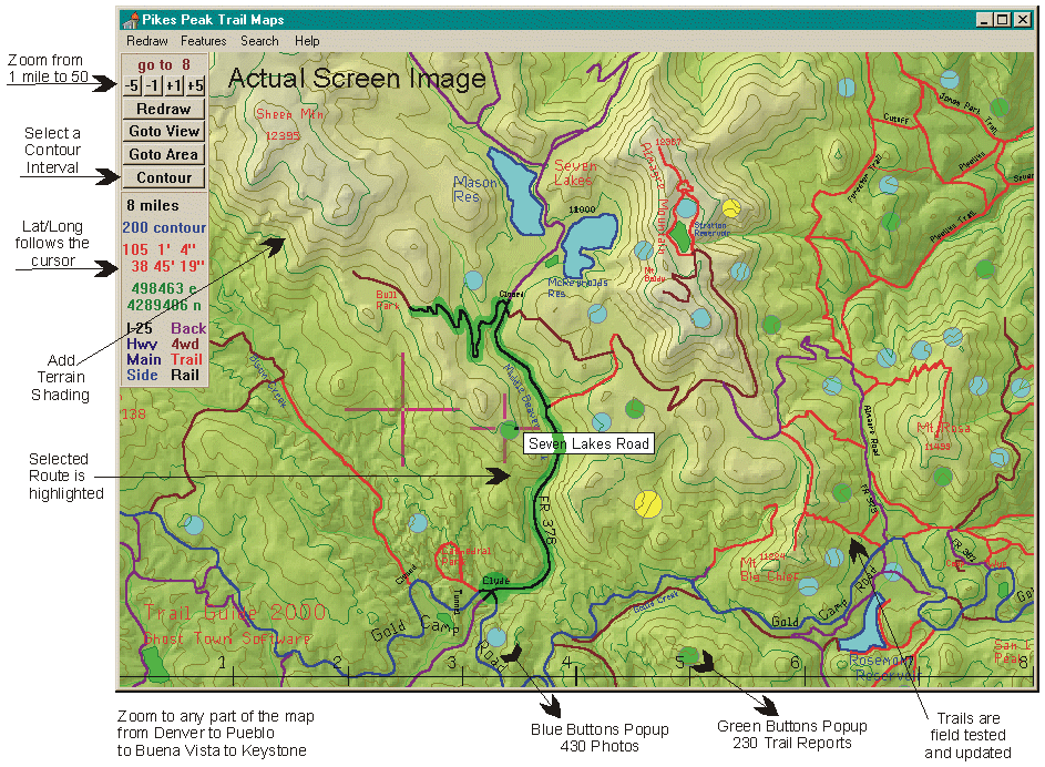
 View a CD screen image Trailguide CD Info Trailguide Book Info Other Colorado Books Free Software Demo Get Latest Fixes |
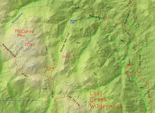 Small view of one of the pages, showing Lost Creek and Cheesman Res. Click the image to zoom in to the yellow region and see the level of detail in the printouts. |
|
|
CD Map Features Maps cover an 80x100 mile area, from Pueblo to Denver to Keystone to Salida. Reports and Photos
Reports and photos pop-up when you click the buttons right on the map,
or you can browse and click a list of the trails.
The reports and photos on the CD are far more detailed than on this web site.
Includes 200 reports on trails and parks from Zoltan Malocsay's 360 page guidebook : |
|
| The Trail Guide CD is packed with trail reports and photos on these areas. Each of these areas has info on several trails. | |
|
Southern Pike National Forest : Pikes Peak Trail System Ute Pass Area Colorado Springs Area Cheyenne Canyon Area Emerald Valley Area Almagre Mountain Gold Camp Road Area Cripple Creek Area Mueller State Park (All 40 Trails) Florissant Fossil Beds N.M. Elevenmile Canyon Woodland Park Area Rampart Reservoir Area Schubarth/Stanley Area Rampart Range Trails U.S. Air Force Academy Monument / Black Forest Area Castlewood Canyon State Park Devils Head Area Beaver Creek Wilderness Royal Gorge Area Pueblo Area |
Northern Pike National Forest : Roxborough State Park Strontia Springs Reservoir Area Colorado Trail 1776 Mount Falcon Park Elk Meadow Park Alderfer / Three Sisters Park Reynolds Park Meyer Ranch Park Deer Creek Canyon Park Denver Mountain Parks Buffalo Creek Bicycle Area Deckers / Cheesman Tarryall Area Lost Creek Wilderness Wellington Lake Area Bailey Area Deer Creek Area Guanella Pass Area Kenosha Pass Area Buffalo Peaks Wilderness |